
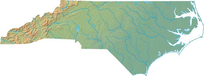
North Carolina Relief Map
Static North Carolina Relief Map
Interactive North Carolina Relief Maps
The interactive relief map choices include a standard Google terrain map and an enhanced Google terrain map with Street View capabilities. To zoom in or out on either of these North Carolina maps, click or touch its plus (+) button or its minus (-) button, respectively. To pan either map in any direction, simply swipe it or drag it in that direction. To display either of these North Carolina terrain maps, click or touch one of the following menu options.
North Carolina's highest mountain is Mount Mitchell, whose peak is 6,684 feet above sea level. The largest lake in North Carolina is Lake Mattamuskeet. If you are planning a visit to North Carolina, please see Visit NC, the official state tourism site, where you can find a wide range of travel and vacation information. For information about North Carolina history and recreational activities, visit the following National Park sites.
North Carolina National Parks
- Appalachian National Scenic Trail
- Blue Ridge Parkway
- Cape Hatteras National Seashore
- Cape Lookout National Seashore
- Carl Sandburg Home National Historic Site
- Fort Raleigh National Historic Site
- Great Smoky Mountains National Park
- Guilford Courthouse National Military Park
- Moores Creek National Battlefield
- Overmountain Victory National Historic Trail
- Trail Of Tears National Historic Trail
- Wright Brothers National Memorial
Copyright © 2005-2024 State-Maps.org. All rights reserved.
North-Carolina-Map.org is a State Maps reference source.
To facilitate browsing, certain external links will open in new windows.
North-Carolina-Map.org is a State Maps reference source.
To facilitate browsing, certain external links will open in new windows.