
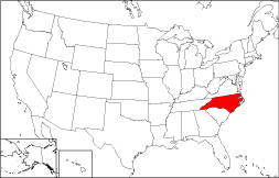
North Carolina Map
|
 |
 |
Where Is North Carolina?
The State of North Carolina, shown in red on the adjacent map, is bounded by Virginia on the north, by South Carolina on the south, and by the Atlantic Ocean on the east. It is bordered by Tennessee to the west and by Georgia to the southwest.
North Carolina Maps
North Carolina is the 29th largest state in the United States, covering a land area of 48,711 square miles (126,161 square kilometers). The pine forests that cover many of the state's 100 counties produce tar, pitch, and turpentine; they account for its Pine Tar State nickname. This North Carolina map site features North Carolina road maps, topographical maps, and relief maps. The detailed, scrollable road map displays North Carolina counties, cities, and towns as well as Interstate, U.S., and North Carolina state highways. The pannable, scalable North Carolina street map can be zoomed in to show local streets and detailed imagery.
North Carolina Highway Map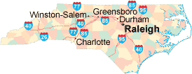 Click on the highway map thumbnail
to view a scalable North Carolina road map. |
NC Topo Map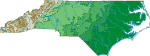 Click map to enlarge.
|
NC Relief Map Click map to enlarge.
|
The detailed North Carolina map and the regional North Carolina map display cities, roads, rivers, and lakes as well as terrain features. The detailed map shows only the State of North Carolina, while the regional map shows North Carolina and the surrounding region.
North Carolina Infrastructure > North Carolina Airports
In 2005, the population of North Carolina was estimated at 8,672,459, which is about 178.3 people per square mile. In 2010, North Carolina's population rose to 9,535,483 people. More recently, in the 2020 census, the North Carolina population was 10,439,388. The state's Interstate Highways include I-26, I-40, I-77, I-85, and I-95.
North Carolina Topography
 North Carolina was named in honor of King Charles I of England.
Swamps and sandy, forested dunes abound in the state's low-lying coastal
plain. In western North Carolina, hills rise gradually toward the
Blue Ridge and Great Smoky Mountains. National Seashores
along the Outer Banks draw visitors during the summer months, while the
Blue Ridge National Parkway draws tourists who enjoy the restful mountain
scenery.
North Carolina was named in honor of King Charles I of England.
Swamps and sandy, forested dunes abound in the state's low-lying coastal
plain. In western North Carolina, hills rise gradually toward the
Blue Ridge and Great Smoky Mountains. National Seashores
along the Outer Banks draw visitors during the summer months, while the
Blue Ridge National Parkway draws tourists who enjoy the restful mountain
scenery.
For North Carolina travel information, visit the official North Carolina tourism site and North Carolina Atlas.
Other Maps of North Carolina
This North Carolina reference map shows major cities, roads, railroads, and physical features in North Carolina.Several map publishing companies offer printed maps of North Carolina. For example, Omni Resources offers several maps of North Carolina that feature points of interest, airports, and parks, as well as selected local attractions and insets of major North Carolina cities.
All rights reserved.
Certain maps hereon are © Map Resources or Digital Wisdom.
To facilitate browsing, certain external links will open in new windows.
North-Carolina-Map.org Editor, State Maps, PO Box 828, Barnegat, NJ 08005.